Best hikes in Banff National Park, Canada

Pictures from the best hikes in Banff National Park in Canada have gone viral on social media these past couple of years. If you only have time for a quick snapshot you may want to check out my post on Instaworthy stops along the Icefield Parkway. But if you are in it for the full experience and really inspired to enjoy some of the best hikes in Banff, read on, for I have an extensive compliation for you!
Upper Falls in Johnston Canyon
by Kristin Lee of Global Travel Escapades

If you’re visiting Banff National Park, one of the best hikes you won’t want to miss is the trek to Upper Falls in Johnston Canyon. This incredible trail is 3.2 miles or 5.1km long with 859 ft or 262 m in elevation, and it usually takes a leisurely two hours to complete. What makes this trail worthwhile is that you get to see no less than four stunning waterfalls along the way, the largest one (Upper Falls) at the halfway point.
The path is well-marked and maintained, making it a very popular trail among locals and tourists. And while this can be a great thing, just know that parking is limited, so you may want to get there early to guarantee yourself a spot. Plus, due to its popularity, the trail can get quite crowded, making an early start all the more important.
That said, if you aren’t able to reach the trailhead early in the morning, consider arriving late in the afternoon. Crowds tend to slowly dissipate after lunchtime.
So if you’re looking for a great outdoor experience with spectacular scenery in Banff, then don’t miss out on this breathtaking hike to Upper Falls in Johnston Canyon.
Lake Louise Lakefront trail
by Anu Agarwal of Destination Checkoff

Distance – 2.8 miles / 4.5 km
Elevation gain – 354 feet / 108 meters
Time needed – Around 1 to 1.5 hours.
Lake Louise Lakefront trail is the most popular and heavily trafficked trail in Lake Louise, Alberta region of Canada. Visiting Lake Louise is a must do in any trip to Banff. The trail runs along the waterfront of Lake Louise starting at the front of Fairmont Chateau hotel and going all the way to the end of the lake. It is out and back and you return back the same route. The trail is around 2.8 miles with very gradual elevation and is considered easy and doable by people of all fitness levels.
The hike has excellent views of Lake Louise, Fairmont Chateau Lake Louise hotel and the surrounding mountains. The lake is frozen during the winter months and in early Spring, and the trail is packed with snow but still walkable with snowshoes. The initial part of the trail is paved but later on it’s a dirt road. It takes around an hour to complete the trail, but the views of Lake Louise and the Fairmont hotel are so spectacular that you will be stopping to take pictures and the surrounding views a lot!
After the hike stop at the Fairmont Chateau lounge for some food and to use the restrooms. You can park at the public parking lot at Lake Louise for a fee.
Marsh Loop
by Shireen of The Happy Days Travels

For a flat trail with minimal elevation gain close to Banff townsite, the Marsh Loop trailhead is the ideal hike. This is a circular walk starting at Cave and Basin Historical Site just a few minutes outside of Banff Town centre. The loop is roughly 2.5km taking an hour to complete but give yourself longer to stop for pictures, spotting wildlife and enjoying nature.
The Marsh Loop trail is at the base of Sulphur Mountain and surrounds the Wetlands while passing the Bow River and views of Cascade Mountain. This is one of the best places to spot wildlife especially in the mornings during Summer but is a popular trail for Horses so is mostly muddy along the way. Although the hike is open in Winter it can get icy and potentially dangerous so always check for safety before starting the walk.
These Marsh Loop tips will help you find the trail, what to do there and how to prepare for the hike. If you want to continue hiking in this area, the Sundance Canyon Trail is nearby.
Vista Lake / Arnica Lake and Twin Lakes
by Kenny of Knycx Journeying

There are numerous things to see and do in Banff, including hiking in the rugged mountains and wilderness. The path between Vista Lake, Arnica Lake, and Twin Lakes is a popular scenic and slightly challenging trail. It’s suitable for experienced hikers from all around the world.
The trail is close to Banff’s town center, Lake Louise and Canmore. The entrance of the trail is on Windermere #93 Highway at Vista Lake Lookout. The hike begins there, followed by a few big up-and-down trails that leads to Arnica Lake.
While the elevation change might be challenging, the trail, however, is quite clear and generally covered by forest. The beginning of the trail is rocky and once it passed Arnica Lake, the path surface could be wet and muddy – it is recommended to wear appropriate hiking boots and visit there on sunny days if you prefer to walk on a dry surface.
The trail ends at Lower Twin Lake and which is located about 8 kilometers away from the entrance. The scenery of the Lower Twin Lake is considered the best of the whole trail, and while the first half of the hike is mainly downward, the return route is mainly walking up back to Vista Lookout.
Visiting the trail is more suitable during summer, but it is also open in winter. There’s a chance to have a bear encounter during the hike, and keep food and drinks properly and safely. Prepare bear spray if needed.
The total distance of the hike is about 16.6 kilometers, the elevation gain is between 800 and 1,000 meters, and it takes about five to six hours to complete (both ways).
Hoodoos Trail
by Karen from Forever Karen

Hikers often pass up the trail to the Hoodoos in Banff because you can view the Hoodoos from a viewpoint. However, hiking down the tall pillars gives you a different perspective of these unique natural wonders.
From Surprise Corner, expect to spend about three hours on this 9.5-km or 5.9-mile out and back trail. The trail has an elevation gain of 115 m or 377 feet, but it has some elevation loss also.
While you can hike the trail year-round, you’ll need snowshoes in winter and be aware of avalanche risks. In summer, you’ll need mosquito repellent and bear spray instead.
Before emerging by Bow River, you’ll hike downwards and around Tunnel Mountain from the Surprise Corner parking area. Following the river, the trail meanders up and down, and from it, you enjoy views of the Fairmont Banff Springs Hotel across Bow River, Bow Valley, and Mount Rundle.
Towards the end of the trail, the hike climbs dramatically upwards, which is why some consider this a moderate trek. At the viewpoint, you’ll marvel at the Hoodoos, a rare occurrence in the Canadian Rocky Mountains. You’ll return back to the parking lot on the same route.
The Banff Hoodoos have undergone dramatic erosion in the last few decades. Outside of Banff, the Leanchoil Hoodoos make a great day hike in Yoho National Park. While this hike is shorter and more challenging, the Yoho Hoodoos are much more impressive.
Fairview Lookout Hike at Lake Louise
by Catrina of 24 Hours Layover

Even if you only have 24 hours in Banff National Park and don’t have much time to explore, you should definitely do one of the short hikes such as The Fairview Lookout Hike. The Fairview Lookout Hike is a 2.4 km (1.5 miles) return hike with an elevation gain of 167 metres (548 ft) that offers absolutely fantastic aerial views of Lake Louise, the mountains and The Fairmont Chateau.
The Fairview Lookout Hike is a nice short hike that should take around 45 minutes to complete. It takes about 20 minutes to reach the viewpoint along the short but steep ascending path. Once you get to the viewpoint, the scenery and the turquoise colour of the lake is simply breathtaking.
To reach the beginning of the hike, head towards the shore of Lake Louise from the parking lot. Go to the left of the lake near the canoes and you’ll see a sign for Fairview Lookout.
As it is a short hike you’ll likely encounter many people along the trail. The summer months of June to August are the best times to do this hike as there is usually snow and ice along the path throughout the rest of the year so it can get very slippery.
Make sure to wear appropriate footwear whatever time of year you visit. This is an easy to moderate hike so most children should find the hike manageable, and dogs are allowed on the path but need to remain on a leash.
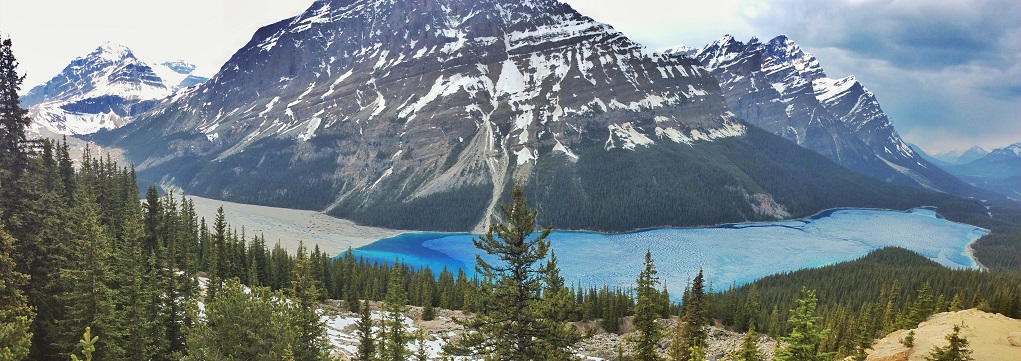
Peyto Lake
by Kristin Lee of Global Travel Escapades

Whether you’re doing a quick visit from Calgary or planning on spending lots of time in Banff, a must-do hike is to Peyto Lake. The hike begins at the Bow Summit parking lot, is only 1.5 miles or 2.4km round trip, and has a slight elevation of 275 ft or 84 m. This makes it a suitable trail for all levels of hikers and takes only an estimated time of 45 minutes to complete.
What makes this trail so worthwhile is the unbelievable panoramic view of Peyto Lake, located at the halfway point. This picturesque lake has a unique aqua-blue color, due to its glacial meltwater, which is visible from the viewpoint! Additionally, this trail offers plenty of photo opportunities for all kinds of nature lovers, such as wildflowers blooming in the summertime.
As if that wasn’t enough, there’s also plenty of parking at the trailhead, which means you don’t need to stress about arriving super early in the morning.
So, whether you’re visiting solo or with friends and family, don’t miss out on this breathtaking hike to Peyto Lake in Banff. It’s one of the most popular trails in the area and a great way to spend the day exploring nature.
Bow Falls
by Shireen of The Happy Days Travels

The Bow Falls is a mini waterfall along the Bow River at the end of the ‘Bow Trail’ walk in Banff National Park. This is one of the easiest and quickest hikes to do in Banff due to its proximity to the town centre, short distance and low elevation gain.
This hike can be taken straight from Banff Avenue in the main townsite and will take roughly 25 minutes each way. Follow these directions for how to find Bow Falls from Banff Town centre. The distance from the Bow River Bridge on Banff Avenue to the Bow Falls is roughly 1.4km which is mainly a flat trail with just 10 miles elevation gain including a few sets of stairs. This hike is ideal for all ages including kids and can be taken at any time of the year (in Winter you may get the chance to see the frozen waterfalls).
You’ll hear the gushing of water before you see the falls and then you’ll have gorgeous views of Rundle Mountain overlooking the Bow River and be able to walk snap pictures on the pebbles/sand in front of the waterfalls especially on a clear day in Summer when the water is turquoise.
Tunnel Mountain
by Campbell of Stingy Nomads

Tunnel Mountain, located only 1 kilometre from the centre of downtown Banff, is the smallest peak to summit around Banff with an elevation gain of 270 metres (885 feet). The Tunnel Mountain hike is a 4.8 km (2.8 miles) return hike of easy to medium difficulty.
This is a great activity for families. The trailhead is easy to reach from downtown Banff by driving, taking a public bus or walking. The return hike takes 1.5 to 2 hours to complete depending on fitness.
Tunnel Mountain has no tunnel, the Canadian Pacific Railway had plans to blast a tunnel through the mountain in the 1800s. The tunnel was never built, but the mountain kept the name. The mountain resembles a sleeping buffalo from a distance and is also known as Sleeping Buffalo mountain.
From the summit of Tunnel mountain there are nice views of the surrounding Spray and Bow river valleys. At the summit there are two red Parks Canada chairs, that are great for a break and for taking photos. The trail is well marked with moderate switchbacks leading all the way to the top of the mountain.
Enjoy nice views of Banff town, the Banff Springs Hotel, Bow Valley, Mount Rundle, Sulphur Mountain and Cascade mountain during this nice hike.
Sulphur Mountain Trail
by Anu Agarwal of Destination Checkoff

Distance – 6.8 miles / 11 km
Elevation gain – 2,480 feet / 756 meters
Time needed – Around 5 hours
Hiking to the top of Sulphur Mountain is the most epic and popular hike to do on any trip to Banff in summer. The hike from the base of the Sulphur mountain to the top is quite challenging and for the experienced hiker. The trail goes through a lot of gradual switchbacks to reach the top of the gondola station.
On the top gondola station, there is a short board walk trail to the true summit at Sanson’s peak. The elevation is what makes this hike difficult. Plan to take a lot of breaks in between to catch your breath. The views are so amazing on the trail that it makes the hike worth it.
Beginner hikers can still reach the top of the Sulphur mountain by taking the gondola and just walking the boardwalk portion of the trail at the top. The gondola makes this trail accessible to hikers of all abilities as they can take the gondola up or down and reduce the duration of the hike.
The views from the top and the boardwalk trail are phenomenal and you can see the Banff town and Bow Valley. The lower and upper gondola stations have restrooms, gift shops and cafes. After the hike you can fuel up at one of the cafes.
Plain of Six Glaciers Hike
by Marianne of The Journeying Giordanos

The Plain of Six Glaciers Hike in Banff National Park is one of the most popular and scenic hikes at Lake Louise. Although rated as moderate, most reasonably fit people should be able to complete the hike.
With gorgeous views of both Lake Louise and the Victoria Glacier, a visit to the historic Plain of Six Glaciers Tea House, and an amazing finish at the Abbot Pass viewpoint, this iconic hike really is worth the effort it will take to complete it.
The complete Plain of Six Glaciers hike is actually made up of three connected trails: The Lakeshore Trail which is flat and fully accessible, the Plain of Six Glaciers Trail which is the longest and steepest portion, and the Abbott Pass Viewpoint which is short and quite challenging, but gets you the best view of the Victoria Glacier.
Of course, before you head to the Abbott Pass Viewpoint, you really show stop at the Plain of Six Glaciers Tea House for a hot cup of tea (or cocoa) and a slice of chocolate cake!
In total, the Plain of Six Glaciers hike should take between 3-5 hours to complete (including a stop at the Tea House). The trail is approximately 14.6 km (9.1 miles) long, with an elevation gain of 588 meters (1,929 feet).
Most of the trails are well-marked, and consist of packed dirt and rock, with some portions that are very uneven. The trail gets pretty slippery when wet, so caution and good shoes are a must.
Sentinel Pass Via Larch Valley
by Caleb of The Pazook Travel Journal

This popular trail is considered one of the more challenging day hikes in the Moraine Lake area, but it is doable for most people. An experienced hiker will finish the 6.9 miles (11.1 km) out-and-back trail in 4 – 5 hours, but beginners or families with young children should allow for 6 hours to take breaks more frequently.
While a topographical map will show a slow incline of 2,621 feet (799 meters) up to the pass, it doesn’t feel gradual. The most challenging sections are the first ascent up from Morania lake, followed by the final climb from Larch Valley to Sentinel Pass. The middle of the hike through Larch Valley is gradual, with open views of the mountains in all directions!
Start early to avoid crowds and ensure parking is available at the trailhead. It is also possible to take the shuttle from Lake Louise, but the trail tends to get jammed up once buses start arriving.
October is the best time to see the fall colors in Banff. Larch Valley is especially beautiful in autumn, as the deciduous pines change from green to a forest of gold!
Note: Be careful doing this hike in late summer, when wildfires are common in the area, since the smoke can heavily affect the views in the valley.
Lake Agnes Teahouse
by Emilie of Love Life Abroad

When searching for a great hike in Banff National Park, the Lake Agnes Teahouse hike is an excellent option. The trailhead starts on the lakeshore of the iconic Lake Louise. This moderate hiking trail in Banff is a 7.4 km (4.6 miles) out-and-back trail with an elevation gain of 400 meters (1,312 feet). It takes about 1 to 2 hours to reach the teahouse (one-way).
During this hike, there are many different viewpoints where hikers can enjoy the view of Lake Louise and its turquoise color. Then at the top, you’ll find something special. Not only will hikers walk past a small waterfall and arrive at little Lake Agnes. But from May to October, hikers will get to enjoy a warm cup of tea (or coffee) at the top of the hike in the historic log cabin-style teahouse.
This trail is open year-round, but sadly when visiting Banff in the wintertime, the teahouse will be closed.
If times allow, there are a few options to extend this hike a little. From Lake Agnes, you can hike to the Little Beehive or the Big Beehive following the Little Beehive/Big Beehive route. Depending on the route, it will add 1.5 to 3 km to the hike.
Big Beehive
by Campbell of Stingy Nomads

Big Beehive is a mountain in Banff National Park close to Lake Louise that resembles a beehive. The Big Beehive hiking trail is a route up the mountain of moderate difficulty with spectacular views of Lake Louise.
This 10.5 km (6.5 mi) hike takes about 3 to 4 hours to complete. It has some steep sections and the total elevation gain for the trail is 550 m (1800 ft).
The standard Big Beehive hike is an out and back route starting at Chateau Lake Louise and turning around on the Big Beehive. Following the trail you walk past several lakes; Lake Louise, the Mirror Lake, Lake Agnes you also walk past the Lake Agnes teahouse, a popular stop.
Along the way you will be rewarded with great views of Mount Whyte, the Devil’s Thumb and Lake Agnes. This route starts out with easy flat walking, the hardest part is going up to the top with a series of switchbacks. The Beehive shelter at the end of the trail is a nice spot to have a break or something to eat.
To return from the top of the Big Beehive to the trailhead you can follow the same way down the mountain. Another option is to extend the hike by following the moraine to the Plain of Six Glaciers’ to complete a 12.5 mile (20 kilometre) hike that takes about 7 to 8 hours.
Rockpile Trail
by Jessica of Uprooted Traveler

There’s perhaps not a sight that’s more iconic in Banff than the stunning, Gatorade-colored waters of Moraine Lake, with the snow-capped Rocky Mountains in the background.
If you want to snap a photo of that iconic view, consider an easy hike along the Rockpile Trail. From the parking lot, it’s an easy 0.8 km (0.4 miles) round-trip hike, where you’ll cross a bridge over a stream and continue along the northern shore of the lake.
Along the path, there are several interesting plaques that provide information about the platlife and geology of the area. The trail eventually climbs uphill 30 meters (98 feet) to the top of the eponymous “rock pile” to give a better view over the lake and beyond, the Valley of Ten Peaks. The view from here is so beloved that it’s actually previously been featured on the old Canadian twenty dollar bill.
If you’re visiting during a busy time, like on the weekends or holidays during summer, be sure to show up really early to snag a parking spot. Moraine Lake’s lot is exceedingly tiny and given that it’s one of the most popular things to do in Banff in the summer, the lot often fills up before even 5 AM.
Alternatively, you can take the Moraine Lake shuttle from the Lake Louise Park and Ride. No matter what you do, be sure to plan ahead- seeing Moraine Lake from the top of the Rockpile Trail is not to be missed!
Consolation Lakes
by Manouk of Groetjes uit Verweggistan

One of the most popular destinations near Banff is the beautiful blue Moraine Lake. It is breathtaking as the pictures promise. It is hard to get to: the easiest way is to buy tickets for the shuttle bus between Moraine Lake and Lake Louise. Buy them well in advance. Parking is possible, but very limited. In summer this means you might need to get to the car park at 2 am before it is full.
Moraine Lake is right next to the bus stop. But don’t stop here! Continue your way to the gorgeous Consolation Lakes. The trail starts on the left of the lake. It is clearly marked with signs. Keep an eye out: you might spot some pikas here!
The hike is fairly flat, only 240 m/3.3 ft elevation gain. You walk through a nice forest. Please be careful about bears and do not hike alone. The mountains will slowly reveal themselves on the last part of the path.
The lakes are 3.1 km/1.9 miles (6.2 km/3.9 miles return). Near the lakes, you will need to scramble a bit on the rocks to get to the water. You will be amazed by a beautiful reflection of the surrounding mountains. If you are quiet you might even spot a marmot here. Please be careful and don’t drop anything, the water between the rocks is very deep and cold.
The hike will be a little over 1,5 hours return. Take 2,5 hours if you also want to enjoy some time at the lakes. Don’t forget to climb the Rock Pile on your way back for the best views of Lake Moraine.
Related posts:

0 Comments